Introduction
Cambridgeshire is an inland county of eastern England, bordered by Lincolnshire to the north, Norfolk and Suffolk to the east, Essex and Hertfordshire to the south, and Bedfordshire, Huntingdonshire and Northamptonshire to the west. It extends for 77 km (48 miles) from north to south, and a maximum of 45 km (28 miles) from east to west, covering a total of 524,935 acres and is thus the 27th in size of the 39 counties. The only large town is Cambridge (109,000 in 2001); next in order of size are Wisbech (20,200), March (19,042), Whittlesey (15,580) and Ely (15,102).
Landscape, geology and building stones
In terms of surface geology the county is divided into four parts, which can be called chalk, sand, clay, and fen. The chalk zone is in the SE of the county; south of a line running from Isleham through Cambridge to Litlington. North of this is a greensand band, approximately eight miles wide, and to the north again, occupying a small patch of western Cambridgeshire around Swavesey, Willingham and Conington, is a middle oolitic region of corallian limestone and Oxford clay. The entire northern part of the county is alluvial fenland; low, flat and damp except for a few islands of clay and sand rising above the general level, around Ely, Thorney, Whittlesea and March. The Isle of Ely is the biggest of these, and while it does not rise more than 20 metres above the surrounding peat, it can be seen from miles away.
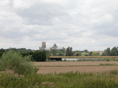
Ely Cathedral, distant view from the SE
The National Trust site of Wicken Fen near Ely is an attempt to reconstruct the old fenland, and today provides a habitat for fen plants, birds and insects, attracting marsh harriers and reed warblers and large numbers of people with binoculars. The sedge that is grown here is again harvested and sold for thatching. The fens did not begin to get their present appearance until the 1630s when the landscape was first systematically drained by the Dutch engineer Cornelius Vermuyden. Hedges were replaced by a network of ditches draining into cuts and subsequently rivers to produce a flat and open arable landscape very different from the medieval fenland. The fens, of course, provide no building material except reed for thatching, which was commoner in the Middle Ages than it is now, but is found at Rampton, five miles north of Cambridge on the edge of the fens.
The chalk geology of the south east offers more possibilities for building stone. Chalk itself is generally soft, but the deposits contain harder, more compressed areas, variously named clunch, or Barrington or Cambridgeshire clunch, or Burwell rock, that are still easy to carve but are quite dense too. Being soft and fine-grained, clunch carves very well, and it is occasionally used internally, as on the capitals of the nave arcade at Bourn, south west of Cambridge in the chalk zone.
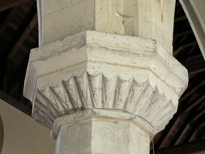
Clunch scallop capital in the S arcade of St Helena's, Bourn
It was extensively used at Denny Abbey, seven miles north of Cambridge and just outside the chalk zone, and has generally weathered well there, but in areas that lost their protection from the weather when the abbey fell into disrepair the clunch has suffered catastrophically.
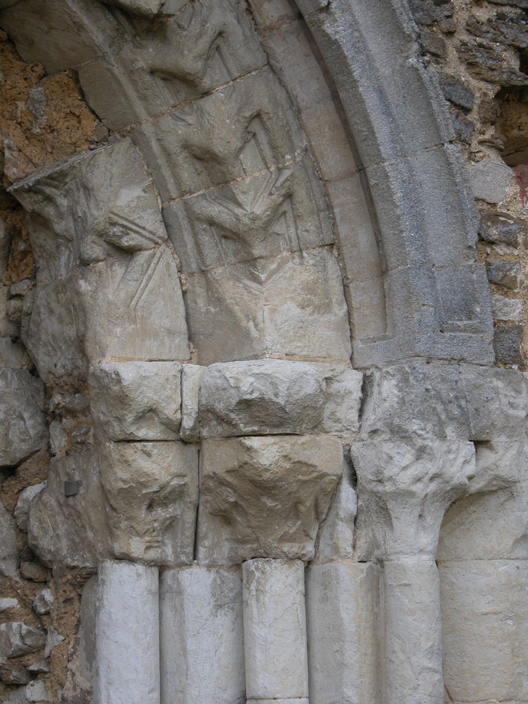
Deterioration of the clunch W doorway at Denny Abbey
Chalk beds contain flint nodules too, of course, and these were widely used for building in this part of Cambridgeshire. In the greensand belt, north of the chalk zone, the orangey brown sandstone called Carstone, or gingerbread stone was used in building. It was quarried in the area around Gamlingay, and St Mary’s Gamlingay is entirely built of it. Carstone is more commonly seen, however, as a component of the mixed flint and pebble facing characteristic of much Cambridgeshire building.
Flint and pebble building at Pampisford, Little Abington and Swaffham Prior
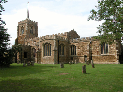
The Carstone church of St Mary, Gamlingay
It should be clear from this brief survey that Cambridgeshire was poorly supplied with its own stone for building and sculpture. If ashlar was required it had to be imported. The nearest quarries were those of the limestone beds to the north west, notably Barnack, King’s Cliffe and Ketton. These workings were in use before the Conquest, as at Barnack itself and Wittering, in the Soke of Peterborough. Barnack stone was used throughout at Ely cathedral, but a more typical example of its use is in the important early-Romanesque church of St Mary Magdalene at Ickleton in the chalk zone. The arcade piers, some of them monolithic, and their capitals, and the west doorway are of Barnack limestone, but the external wall facings are a mixture of local flint and pebbles.
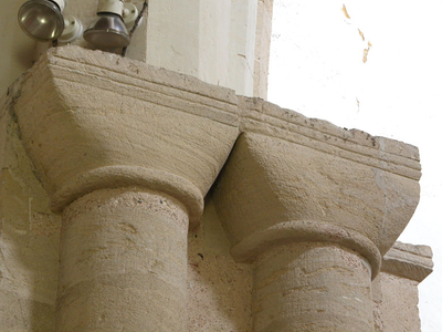
Barnack limestone capitals at St Mary Magdalene, Ickleton
Finally, as in most southern English counties that are poor in their own freestone, fonts of Sussex or Purbeck marble (actually paludina limestone that could be polished) were imported from the end of the twelfth century onwards. These standardized products, either rectangular or octagonal and decorated with simple arcading in low relief, can be seen at Gamlingay and Thriplow.
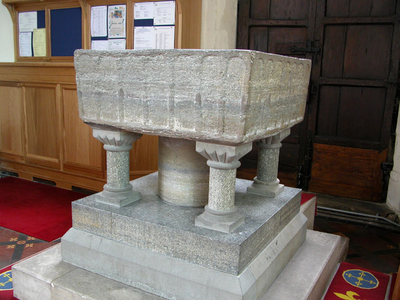
The imported Sussex marble font at Thriplow
Settlement
The landscape affects settlement patterns very obviously in this county. In 1086 and still today the fenland had few settlements, and those that existed were on the islands noted above. Dispersion densities were similarly low in the fenland, and remain so today. By contrast, the southern parts of the county, roughly south of Cambridge, had more nucleations and a higher density of dispersion. This pattern is clear from the configuration of Domesday settlements and the map of Romanesque sites in the county, as well as the hundreds into which the county was divided. In 1086 there were sixteen hundreds; the two hundreds of Ely (later called Wichford and Wisbech) covered practically the entire expanse of the fenlands. The south of the county was divided into fourteen hundreds of much smaller size. Darby has analysed population densities throughout the county based on the figures given in Domesday, and reports that the fenland hundreds had between 0.9 and 3.3 people per square mile, while in the south the densities of rural settlement varied from 6.2 per square mile (Staploe hundred) to 13.9 (North Stow and Chesterton hundreds).
Evidence of human settlement in the county is continuous from the Palaeolithic period onwards. The Romans colonised the fens, building a sea wall around the Wash to keep out the highest tides, digging various canals and building the Fen Causeway from Downham Market to Water Newton (Durobrivae), and using these routes to take out salt and beef. The Fen Causeway passes close to March and Whittlesey, and evidence of Roman settlement has been found around the former. At Water Newton the Fen Causeway crosses Ermine Street, which runs south through Godmanchester (Durovigutum) and Cambridge (Duroliponte). Water Newton, Godmanchester and Cambridge were all Roman towns. Cambridgeshire also contains one of the most spectacular monuments of early Anglo-Saxon England in the Devil’s Dyke, an earthwork dated to the end of the sixth century or the beginning of the seventh. It runs in a south-easterly direction for 12 km (7.5 miles) in a straight line from Reach to Ditton Green, across the chalk belt, and has a ditch on its west side and a bank on the east. The height from the bottom of the ditch to the top of the bank is approximately 10.5 metres (34 feet). It was thus built to prevent incursions from the west, and probably marks the boundary of the East Anglian kingdom. Fleam Dyke is a similar but less imposing earthwork running parallel to the Devil’s Dyke some 10.5 km (6.5 miles) to the south west. The early Anglo-Saxon period also saw a good deal of monastic settlement; Ely, Thorney and Peterborough were all founded in the seventh century, and the higher, afforested land was cleared and used for pasture – a process called assarting. Cattle farming was the main activity, but in addition the natural products of the fens were harvested; fish of course, and reed for thatching and peat for fuel.
Administrative history
References to Cambridgeshire in the Corpus of Romanesque Sculpture are to the traditional or ancient county as described in Domesday, but Cambridgeshire and its neighbours, especially Huntingdonshire, have undergone administrative changes over the last two hundred years, which can confuse the uninitiated and require some explanation. The Liberty of Ely dates to Edgar’s charters for the refounded monastery in 970, when he gave the abbot the soke over the two hundreds of Ely, comprising between them the entire area of the fens, and over his other possessions outside the Isle. What this soke entailed is a matter of debate, but certainly by the mid-11thc the abbot was holding courts, and jurisdictionally the Liberty was a county in its own right. Later, as we shall see, a distinction was drawn between Ely’s possessions in the Isle and those outside it. These rights were confirmed by the Conqueror, and passed to the Bishop of Ely when it became a diocese. The Isle of Ely was under the jurisdiction of the Bishop of Ely from 1109 until 1837. In that year the bishop’s secular powers were taken from him by the Liberty of Ely act, and the Isle of Ely became a division of Cambridgeshire. When county councils were introduced in 1888, the Isle became effectively a county in its own right, with its own elected council. This situation endured until 1965, when Ely and Cambridgeshire were merged to form the county of Cambridgeshire and Isle of Ely. At the same time the rural district of Thorney, in the north west of the county, was designated part of the county of Huntingdon and Peterborough (for more information about this hybrid, see the Preface to Huntingdonshire). In 1974 the counties of Cambridgeshire and Isle of Ely, and Huntingdon and Peterborough were merged into a single county called Cambridgeshire (Thorney thus returning to Cambridgeshire). A district called Huntingdon within Cambridgeshire had approximately the same boundaries as the old county of Huntingdonshire, and in 1984 this district council renamed itself Huntingdonshire district. In 1998 the City of Peterborough was removed from the county for administrative purposes, becoming a unitary authority.
Cambridge
Cambridge is the only major town in the county and the only Domesday borough. It lies on the river Cam (formerly called the Granta) a tributary of the Great Ouse, at the southern edge of the fens. Its Roman name was Duroliponte, and it was called Grantacaestir or Grentebrige from the time of Bede to the Domesday Survey. By the fourteenth century, Grentebrige had become Cambrugge; a change that Ekwall attributed to Norman influence. The onomastic confusion is compounded by the existence of the village of Grantchester, SW of the city, and the designation of a tributary of the Cam as the Granta (although it does not pass through Grantchester or Cambridge). In the Domesday Survey Cambridge was described as a borough of ten wards, containing a total of 373 messuages before the Conquest, 49 of which were waste (empty) in 1086, and 27 of which had been destroyed to build the castle. It was a town of some size in the Confessor’s reign, and the church of St Benet dates from that period. In all there are eleven medieval parish churches surviving in the town, five of which contain twelfth-century work. These are St Botolph’s, St Giles’s Castle Street, St Mary the Less, St Peter’s Castle Street and the Holy Sepulchre, and just outside the centre is the Leper chapel of St Mary Magdalene at Stourbridge. No fabric of the castle mentioned in Domesday survives; all the stone having been quarried for use in the college buildings, but there is an imposing motte. The foundation of Cambridge University is normally dated to 1209, when scholars migrated there from Oxford after that university went into voluntary suspension as a protest after two of its scholars were hanged for murder. At that time, although there was no university in Cambridge, there was certainly a school of sufficient distinction to attract the dispersed scholars from Oxford. The university status of the town was confirmed in a bull of Gregory IX of 1233. The oldest college, Peterhouse, was founded by Hugh Balsham, Bishop of Ely, in 1284.
Cambridge churches: St Botolph's, St Peter's Castle Street and the Holy Sepulchre
Other towns
Wisbech is the largest town in the Cambridgeshire fens, and although it is now eleven miles from the sea it was formerly a port on the estuary of the Great Ouse. It was clearly an important fishery in the eleventh century. Domesday records a total annual catch of 21,500 eels supplied to the abbots of Ely and Crowland and to William de Warenne. The Great Ouse estuary became silted up, causing extensive flooding in 1236, and around 1300 it was diverted to a new outflow at King’s Lynn. This dramatically curtailed the town’s usefulness as a port, but around 1480 a new channel, Moreton’s Leam, was cut to straighten the course of the Nene so that it ran from Peterborough, through Wisbech to the Wash. The old course of the Nene still remains, running through March and Outwell to join the Great Ouse at Downham Market. The new cut promptly silted up again, and it was not until Vermuyen constructed his sluice in 1631 that the port of Wisbech began to recover. It is still an active port for vessels up to 2,500 tonnes, trading timber, bricks, fertiliser and grain with ports in Holland and Scandinavia. The town itself stood in the loop formed by the meeting of two watercourses; the Wysbeck and the Well Stream. The former is now represented by the main course of the diverted Nene, and the latter has all but vanished, but the plan of the town still respects this loop in its curving street lines, and is largely sited on the east bank of the Nene. At the centre stood the Norman castle (a Regency villa now stands on the site) overlooking the market place. An older market place (called the Old Market as early as 1221) is on the opposite (west) bank of the river.
March is another island in the fens, and there is evidence of Iron Age settlement three miles to the south east at Stonea. The Roman Fen Causeway ran just to the north of March, and there is significant evidence of Roman settlement too, including an enormous camp near the Stonea hill-fort. The old course of the river Nene runs through the town from west to east, and the town may owe its growth to the presence of a ford on the road from Ely to Wisbech. It also has some history as a port on the Nene for the coal and grain industries.
Religious history
The Isle of Ely was given by Anna, King of the East Angles, to his daughter Etheldreda as a dowry when she married Tonbert in 649. After her second marriage, to Egfrid King of Northumbria, she took the veil and in 673 she returned to Ely and founded a nunnery there, endowing it with her entire principality of the Isle of Ely and becoming its abbess. When she died in 679 she was succeeded as abbess by her sister Sexburga who ruled the abbey until her death in 699, when she was succeeded by Ermenilda, her daughter. On Ermenilda’s death, her daughter Werburga became abbess. There may have been a community of monks here as well as the nunnery at this time, but in 870 Ely abbey was destroyed by the Danes and when it was refounded by St Aethelwold and King Edgar in 970 it was as a house of monks only. At this time it was in the enormous see of Lincoln, but around 1105 its abbot, Richard, suggested the formation of a see at Ely to relieve the pressure on Lincoln. This was agreed by the pope and King Henry I in 1108-09, and the first bishop Harvey, formerly bishop of Bangor, was elected in the latter year. The diocese consisted of Cambridgeshire alone, and was thus much smaller than the present Anglican diocese.
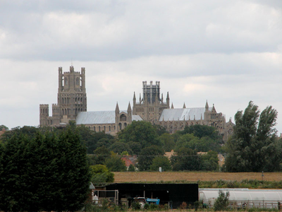
Ely Cathedral from the SE
Thorney was similarly founded in the seventh century, traditionally by Saxulf, Abbot of Peterborough who established a community of anchorites there. It was also destroyed by the Danes, and refounded by St Aethelwold (in 972). Aethelwold endowed it with lands that he bought himself, mostly in neighbouring Huntingdonshire. Although he was the Bishop of Winchester, Aethelwold retained for himself the titular abbacy of Thorney, reserving the right to name his successor. He cleared the island of its thorns and nettles and established a community of twelve monks, enriching the spirituality of the place by the import of relics, most notably the bones of St Benedict Biscop and St Botolph.
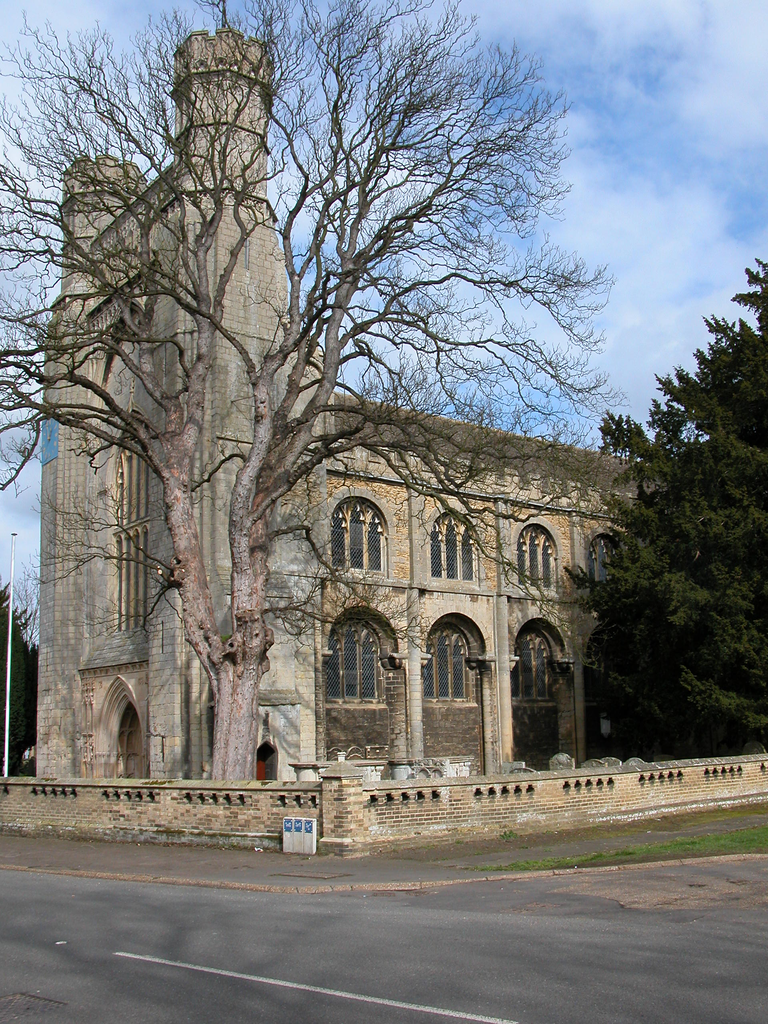
St Mary's Thorney
In addition to these two Benedictine monasteries, Cambridgeshire contained Benedictine nunneries at Chatteris, Cambridge (St Radegund’s), Ickleton and Swaffham Bulbeck. There were no Cluniac or Cistercian houses, but houses of Austin canons at Anglesey, Barnwell and Spinney. The Gilbertines had three houses of canons, at Cambridge (St Edmund’s), Fordham and Marmont. The Knights Templar had preceptories at Denny, Duxford and Great Wilbraham, while the Hospitallers had preceptories at Chippenham and Shingay. There were six friaries in Cambridge itself, representing the Dominicans, Franciscans, Carmelites, Augustinians, Friars of the Sack, and Friars of St Mary. Barham had a house of Crutched friars, and the minoresses had houses at Waterbeach, Denny (formerly the Knights Templar preceptory) and Cherry Hinton. There were two hospitals in Cambridge and others at Stourbridge, Ely, Royston and Wisbech. Alien priories were represented by Linton (Isleham) and Swavesey. Of these, Ely, Thorney, Ickleton, Denny, Stourbridge (St Mary Magdalene’s church, Cambridge) and Isleham retain at least some of their twelfth-century buildings.
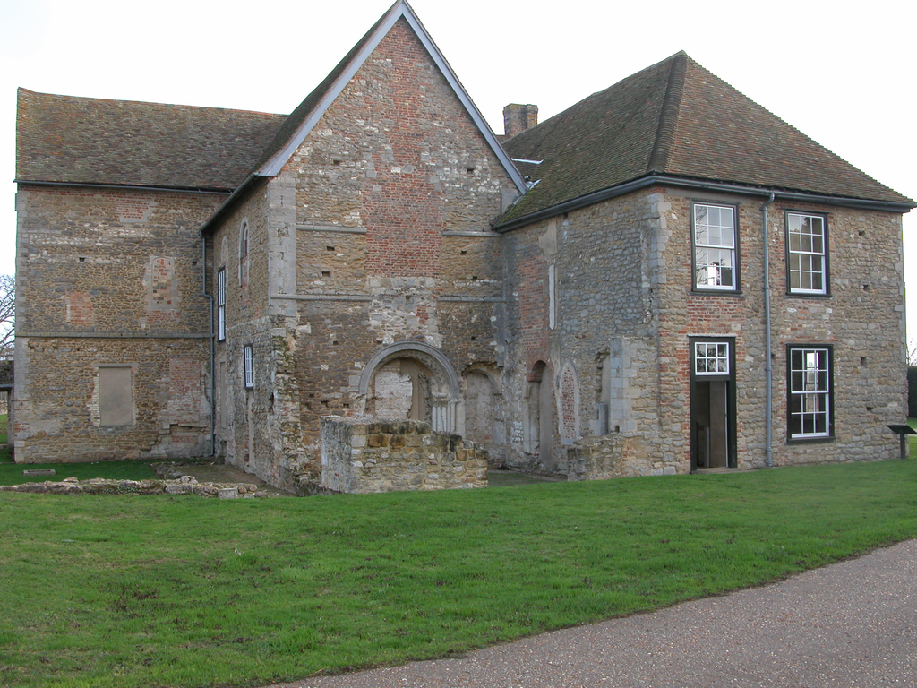
The former Knights Templar Preceptory of Denny
Cambridgeshire after the Conquest
The Isle of Ely is well-known as the centre of the resistance movement against the Norman occupation, led by Hereward the Wake. Contemporary evidence of Hereward’s activities is sketchy in the extreme, but it seems certain that he was a south Lincolnshire squire who held his land from the abbots of Crowland and Peterborough before the Conquest. When the Danish king Swein Estrithson set up his headquarters on the Isle of Ely in preparation for a coup, he was joined by locals antagonistic to the Normans, and in particular to the appointment of Turold as abbot of Peterborough. Hereward was among these, and led an expedition to loot the contents of the treasury of Peterborough before Turold could lay hands on it. He was successful in this, and the valuables were delivered to the Danes, who sent them home to Denmark. Ely had by now become a centre of disaffection, and Hereward was joined by others opposed to the king, including Earl Morcar of Northumbria and Bishop Æthelwine of Durham. In 1071 King William felt constrained to take things into his own hands, and led an expedition against the rebels, bottling them up by blockading the port and laying down timber causeways across the fens to allow his army to advance. The Ely men soon surrendered, and were punished, generally by mutilation, although Hereward himself managed to slip away with some of his followers, and was not heard of again. The north of the county remained part of the Liberty of Ely, under the abbot, then the bishop, as we have seen, but in the south of the county Picot, lord of Bourn and Madingley, was the sheriff by 1071, a man described by the Abbot of Ely as “a hungry lion, a ravening wolf, a cunning fox, a dirty pig and an impudent dog,” who is best known for his attempts to rob the Bishop of Rochester of his manor of Isleham by bullying the shire court into testifying against him. He also demolished 27 houses in Cambridge to build a castle, seized lands and raised taxes in the county. The Conqueror seems to have valued him; presumably he felt that a strong sheriff was necessary to counteract the possibility of rebellion from Ely, and gave him considerable grants of land in the county, and on the positive side, he founded St Giles’s church in the city (later Barnwell priory) in 1092 and giving it a generous endowment, in fulfilment of a vow made by his wife, Hugoline.
During the twelfth century the power of the king’s itinerant justices was increased at the expense of the sheriffs, and at that time the position of the Liberty of Ely was not entirely clear. Ultimately a distinction was made between the cathedral’s possessions in the Isle of Ely and those outside it. The Isle was immune to the extent that the king’s courts exercised no jurisdiction within its boundaries, although the possessions of the cathedral outside the Isle were not immune, a state of affairs that was confirmed by Richard I in 1189.
Romanesque architecture and sculpture
Ely is the cathedral of Cambridgeshire. The present building was begun in 1082 by Abbot Simeon and the entire transept and the nave to the west end, including a west transept are Romanesque work. A western Galilee porch was added in the 13thc. (1198-1215), and the original Romanesque chancel was extended to the E with a six-bay retrochoir, completed in 1252. In 1321 the Lady Chapel was added to the N of the choir, and a year later the crossing tower collapsed. The octagon, built to replace it, was completed by 1342, and in the same campaign the remaining bays of the 11thc. chancel were replaced. The earliest capitals, in the transepts, are of the Norman volute type, sometimes with low-relief carvings of birds, beasts and foliage on their bells, but the capitals of the nave, completed in the 1120s, are very plain cushions for the most part.
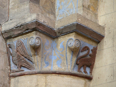
Volute capitals S transept, E arcade of Ely Cathedral
The upper levels of the west transept, decorated with blind arcading inside and out, date from the period of Bishop Geoffrey Ridel (1174-89). The cathedral is also liberally supplied with corbel tables, with human, beast and grotesque imagery covering the entire twelfth century. There is no doubt, however, that Ely’s greatest contribution to Romanesque sculpture is in the doorways from the cloister into the church, especially the Prior’s and Monks’ doorways.
Details of the Prior's Doorway and the Monks' Doorway at Ely Cathedral
The former, Italianate in design but with a Christ in Majesty tympanum inspired from Burgundy, was copied within the county at Kirtling and outside it at Water Stratford (Bucks). The cloister doorways are encrusted with foliage sculpture based on Winchester acanthus but liberally supplied with blossoms, for which Zarnecki has found a parallel in the south doorway tympanum at Wordwell (Suffolk). St Peter’s church at Wentworth is also indebted to Ely; its north doorway having a tympanum supported on corbels with rolls, similar to those on the interior north transept doorway of the cathedral and on the replaced cusps of the Monks’ doorway. Wentworth’s main claim to fame, however, is the relief figure of St Peter, now in the chancel. The Infirmary at Ely is also justly renowned for its sculpture, containing as it does a rich variety of variants on the scallop capital with elaborate chevron ornament, some free-standing, in the arches.
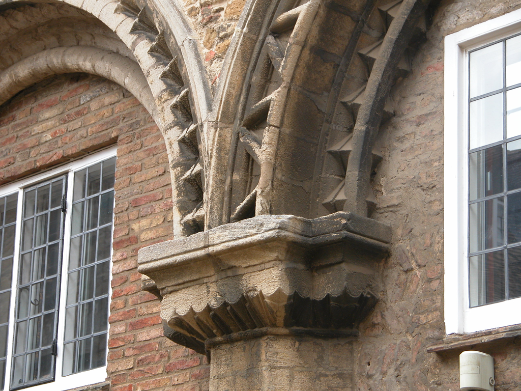
A detail of the Infirmary arcade at Ely
This is usually dated to the 1170s or ‘80s, although there is a possibility of a date in the 1160s. Related high-quality later-Romanesque sculpture is found at various sites in the county: Denny Abbey (founded 1159), St Mary’s, Ely and St Andrew’s, Soham.
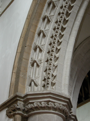
A detail of the crossing arch at St Andrew's Soham
Complete Romanesque churches are extremely rare. The finest is certainly the large cruciform church of St Mary Magdalene at Ickleton; an aisled church with piers and tectonic capitals of Barnack limestone stone. It dates from c.1100, and is architecturally interesting but extremely plain. The leper chapel of St Mary Magdalene, Cambridge, is a complete church of the 1130s with a good deal of chevron ornament, and Isleham priory church a complete church of c.1100, but both fell into disrepair at various stages in their histories and were converted into barns. The former was comprehensively restored by Sir George Gilbert Scott in 1867, the latter more sensitively by English heritage in the 20thc.
Smaller Romanesque churches: St Mary Magdalene's, Cambridge and Isleham Priory
The Holy Sepulchre in Cambridge is a round church of c.1130, but little of its sculpture is original. It was inventively restored by Salvin in 1841. In general, however, Cambridgeshire is not a rich county for Romanesque sculpture due no doubt to the scarcity of suitable local freestones. There are doorways worth seeing at Little Downham (a clunch doorway with heads in the arch and carved nook-shafts), St John’s, Duxford (again clunch, with a cross on the tympanum and chevron on the arch, and Pampisford (with scenes of St John the Baptist in the tympanum). Carved fonts are found at St Peter’s, Cambridge (with sirens on the angles), Madingley (with an exuberant display of geometrical carving), and Great Wilbraham.
Fonts at St Peter's, Cambridge, Madingley and Great Wilbraham
Recording
Fieldwork and photography was carried out by Ron Baxter between June and December 2003 and he also wrote the site reports. Photography was done using a Nikon Coolpix 5700 camera. The images were edited and prepared for web delivery by Anna Bentkowska-Kafel and the web pages were produced by Sophie Church. The author would like to thank the clergy and churchwardens of Cambridgeshire for their generous help in arranging access to the churches in their care, and the bursar and staff of Ely cathedral for their unfailing goodwill and cooperation. Grateful thanks are also offered to the staff of the Farmland Museum and Denny Abbey for facilitating my work there.
Short bibliography
The Cambridge Antiquarian Society was founded in 1840, and publishes annual Proceedings and occasional publications, which are well worth searching. Only general works are listed here; for specific bibliographies, see the individual site entries.
- S. Bradley and N. Pevsner, The Buildings of England: Cambridgeshire, New Haven and London 2014.
- H. C. Darby, The Domesday Geography of Eastern England. Cambridge, 1952 (3rd ed. 1971), 264-314.
- C. H. Evelyn-White, County Churches: Cambridgeshire and the Isle of Ely. London 1911.
- C. Hicks (ed.), Cambridgeshire Churches, Donington, Lincs, (Paul Watkins) 1997.
- A. G. Hill, Architectural and Historical Notices of the Churches of Cambridgeshire. London 1880.
- F. S. L. Johnson, A Catalogue of Romanesque Sculpture in Cambridgeshire and the Isle of Ely. M.Phil (London, Courtauld Institute), 1984.
- P. Meadows and N. Ramsay (ed.), A History of Ely Cathedral, Woodbridge 2003.
- N. Pevsner, The Buildings of England. Cambridgeshire, Harmondsworth 1954 (2nd ed. 1970).
- Royal Commission on Historic Monuments for England (HMSO), An Inventory of Historical Monuments in the County of Cambridge, 2 vols, I : West Cambridgeshire (1968), II : North East Cambridgeshire (1972).
- Royal Commission on Historic Monuments for England (HMSO), An Inventory of the Historical Monuments in the City of Cambridge, 1959, second impression 1988.
- Victoria History of the Counties of England: Cambridgeshire and the Isle of Ely, 10 vols, 1938-2002.
- G. Zarnecki, The Early Sculpture of Ely Cathedral. London 1958.


