Landscape, Geology and Building Materials
The East Riding is open arable upland framed in enclosure hedges, placid pastel vistas and sudden private valleys with sheep; a wall of dark hills on the way to Scarborough; small villages of local brick reached by roads going nowhere in particular; beautiful Beverley, huge Hull and the Humber Bridge. It has a wiggling northern and western boundary somewhere out in the vale of Pickering and the vale of York. On the south the wide Humber gathers all the brown soils of Yorkshire, and on the east the grey North Sea scythes away at Holderness in one smooth curve for 35 miles from Bridlington to Kilnsea.
The most obvious solid geology is the outcrop of the chalk which makes an escarpment to both west and north, overlooking the vales and underlying the Wolds with their interesting periglacial geomorphology. The highest parts of the Riding are along the top of the chalk escarpment, with spots over 200m (650ft) between Givendale, the corner at Acklam, and round to Wharram Percy.
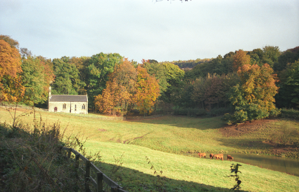
St Ethelburga, Great Givendale in its Wolds setting
From the tops, the general surface slopes very gently down to the south and east. There are farm buildings that use the hard chalk around Folkton and Reighton, and it is occasionally seen inside churches. Chalk serves usually as filling between ashlar faces and occasionally, as cobbles from the beach, for floors; excavators found it used as paving in the priories of Warter and Watton. Its use for structural work is usually minor, such as the window splays lined with chalk at Foston-on-the-Wolds and the later arches of the north arcade, but at Nunburnholme the tower arch carvings seem to be in chalk too. From Driffield and Beverley eastwards the apparently solid land is not chalk but was dumped relatively recently by the last ice-sheet, and this loose material will inevitably erode quickly as sea level rises. The font from Auburn, one of several settlements lost to the sea in medieval times, is now at Wragby, near Nostell, in the West Riding.
The font from Auburn, now in St Michael's, Wragby (West Riding)
Cobbles from the beach, often of igneous rocks from Scandinavia, were gathered for footings at Speeton, for walls at Tunstall, and neatly arranged for flooring at Hunmanby and Reighton (reset). Assorted stones from the glacial deposits in the fields themselves were used for random walling in the villages.
The chancel of All Saints, Tunstall, built using beach cobbles
The quarried stone used most often in the Riding in the early twelfth century was a Corallian oolitic limestone from narrow outcrops just below the chalk, these occur from Filey round through North Grimston and south to Newbald, also in the Howardian Hills. The Birdsall Calcareous Grit has been identified at Weaverthorpe church. This stone type seems to have been used for the cylindrical fonts so popular in the Wolds, as well as for church buildings. This meant a long haul overland, so where possible stone would have been brought in by water, probably from the Filey area. One better stone was found in a limited outcrop south-west of Malton, this was the Hildenley limestone; it was used at Kirkham Priory, for example.
In the vale of York, at Stillingfleet for example, the Tadcaster limestone could be brought by water close to the villages, but it was the thirteenth century before fragments of carved Magnesian limestone are recorded from Bridlington priory, and John Bilson found none used in Beverley Minster before the fourteenth century. A font at Thorngumbald is possibly in Caen stone, the church belonged to St Martin d’Auchy in Normandy and the Humber shore was close to the village at that time. It may be that other possessions of alien Norman abbeys in the region also used Caen stone, but that has not been ascertained. Oolitic stone of a different lithology at Brantingham near the Humber was used later in the century. The Jurassic freestone used in the Riding has not proved to be so durable as stones of the same age quarried further south in England, it had been formed under different conditions. It fractures or the matrix decays, increasingly so at the present time. Many village churches have long been a patchwork of ashlar, brick and cobble, as at Lockington and Brandesburton.
St Mary, Lockington - a patchwork of ashlar and brick
History
With its open chalk downland for pasture and lowlands rich with fish and fowl, the East Riding was hospitable to prehistoric cultures for thousands of years, from the Star Carr finds 11,000 years old, to the Pocklington chariot burials, mere Iron Age, with a variety of major and minor remains in between – the largest single standing stone in England is in the churchyard at Rudston, where there is a fine twelfth-century font.
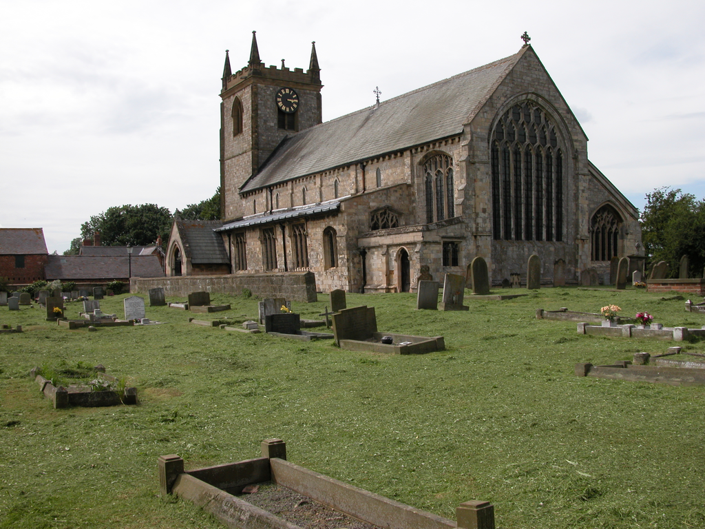
Settlements must be near water, and in the chalk Wolds that meant making a pond or following the spring-line, or the course of the Gypsey (that is, variable) Race, which flows intermittently down the Great Wolds Valley. Towns grew on reliable rivers – notably Beverley on the Hull, and a succession of ports on the Humber shore, from Brough at the Roman crossing to Ravenser Odd off Spurn, and now, of course, Hull. In the twelfth century, Hessle was the port on the Humber. On the sea coast, only Bridlington and Filey had any shelter, and Bridlington was the more important harbour: it was given to the priory by King Stephen.
After the Romans, the Anglo-Saxons, Danes and Normans in turn invaded: the Riding had more radical upheavals than parts to the south west. Peaceful interludes allowed, for example, St John of Beverley to found a monastery in the eighth century, and the Nunburnholme cross was erected later in the Anglo-Scandinavian period, but there are no standing buildings of certainly pre-Conquest date. To judge by place-names, at the time of the Norman Conquest there were settlements over the more marginal lands of the Wolds as well as in the surrounding lowlands.
The Victoria County History says the returns for Yorkshire in Domesday Book ‘are not so full of detail or interest as those for other counties in the east and south of England, nor do they contain much material to illustrate the administrative, industrial or judicial arrangements of the time. No arts and crafts are mentioned, save iron-working only’ (in the North Riding). The king held land throughout the middle of the East Riding, that is, land that was not low-lying but open and probably good arable or pasture; the Archbishop of York’s land was fairly evenly distributed, he and Drew de Bevrere (later, Odo of Aumale) were the only land-holders in Holderness, the area east of the river Hull. Another major land-holder had been Robert count of Mortain, but in 1088 he was banished with his brother Odo, Bishop of Bayeux, forfeiting his English fief. The Gant and other families received these estates. Because of the internal and external threats, from Scotland and from overseas, William needed strong men he could trust in the Riding, and allowed more compact lordships than elsewhere.
Socmen and rights of soc are a special feature of English counties with populations of Scandinavian origins; they indicate men with some independence of holdings or other rights. In settled times, socmen might combine peaceably, for example, it seems that many small land-holders petitioned Bridlington Priory and joined together to build or rebuild the church at Bempton. Socmen are mentioned in the Domesday survey, and there is a notable lack of a slave class in the area. This suggests the existence of a culture in the East Riding not subdued along with the Anglo-Saxons at Hastings. The independence and confidence of this population and its links to cousins overseas encouraged rebellion. A major rising was put down in 1069-70 by King William in person, in a campaign known to history as the Harrying of the North.
The chroniclers, sometimes monks with native sympathies, suggest the dislocations caused by the Harrying were still visible 50 years after the event, that is in the 1130s, but it is hard to quantify the effect, and theories are still being offered to account for the large tracts of ‘waste’ on the Wolds in Domesday. Whereas taxable value was commonly increased under the Conqueror, in this area it had greatly reduced since the time of King Edward. The only obvious measures taken to improve things are that, between about 1109 and 1132, three Augustinian priories were established around the Wolds. These priories were at Bridlington, Kirkham and Warter. The Augustinians canons were a favourite tool in border areas or poor uplands, recognised by King Henry I and Archbishop Thurstan as being able to impart a degree of order through their pastoral work. Certainly a great number of simple churches provided with cylindrical fonts were built in the first half of the century in this area of the Riding. Sculpture at churches is naïve and untutored: but buildings at the priories themselves are much reduced and give only hints of what was possible where funds were available.
It is only after c.1150 that the Cistercian houses in the south of the Riding, Meaux and Swine, were founded. Watton (Gilbertine) is of similar date, and of course all three were enclosed communities. When the desire to rebuild, enrich or extend parish churches arose towards the end of the twelfth century, it is Cistercian or Gothic forms that take over, probably influenced from these sites and their skilled workmen. Round-headed doorways seem to have lasted longer than other Romanesque architectural features, being used at Hedon, Great Driffield, etc. but with repetitious, if refined, mouldings. Interestingly, sculpture continues to use motifs of the earlier period. Such carving is likely to be on nave arcades, as for example at Hayton where a variety of isolated foliage and other forms are arranged around the hollow chamfer of square capitals. A striking instance of continuity among sculptors is recognisable in the carving of a man’s head on the doorway, right side, second order, at Lockington, and of another on a spandrel of the north arcade at Rillington. The time gap is something like thirty years.
Major Buildings
Distant views of Bridlington and Kirkham Priories
The major communities in the East Riding in the first half of the twelfth century were the three Augustinian priories of Bridlington, Kirkham and Warter. At the same time, the canons of St John of Beverley replaced a late Saxon minster with a Norman one on their ancient site; this was again renewed after a fire in 1188. The Cistercians settled at Meaux c.1150, and Swine, for their nuns, was built about the same time, as was Nunkeeling for Benedictine nuns. Two less common orders also had houses in the Riding, that is, the Augustinian order of St John of Jerusalem at North Ferriby, and the Gilbertines at Watton.
The church of St Mary, Swine, incorporates part of the choir of the Cistercian Nunnery
Of these, only traces stand. The area was rich in the later Middle Ages, and rebuilding wiped out, for example, the post-fire Beverley Minster and Bridlington’s Romanesque priory church. The Dissolution must have seemed like the opening-up of new quarries for this area, so poor in its own stone. Warter and Watton are known only from their excavation reports. Kirkham is cleared virtually to the last dramatic buttress, a romantic (Romanesque) arch and half the gatehouse. It might seem as though there had been no great buildings with quality sculpture in this Riding in the twelfth century - but see the cloister arcades reconstructed in Bridlington priory church, the figures reset in Etton parish church, or the double capital displayed in the gallery at the Hull and East Riding Museum, and know that first impressions can be very misleading.
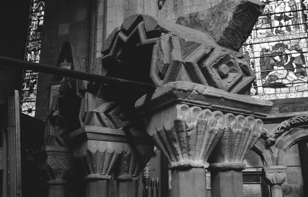
One of the reconstructed cloister fragments at St Mary, Bridlington
As for architecture, if Newbald pictures for us the strange York Minster of Thomas of Bayeux, it is just as likely to have been modelled on its nearer contemporaries, the first churches of the three Augustinian priories round the Wolds, for the aisleless nave was often used by Augustinian architects.
Lesser Buildings
The typical village church of the early twelfth century in the Wolds and Holderness was simple, unless it had some direct connection to a community or an official whose interest required, or whose purse could afford, something grander. Even Kirkburn, Newbald, and Weaverthorpe, which had those advantages, are not spectacular, not in the way that the ‘Yorkshire School’ doorways at Riccall and Stillingfleet are - but those West Riding churches are a decade or two later.
Doorways at Kirkburn and Newbald
It would have been good to see the complete churches at Etton and Bishop Wilton. The East Riding struggled to regain prosperity, it was off the beaten track to York and short of good stone so that, even if trained stonemasons and sculptors came to a major site, there was not much to stay on for after that was built. The first village churches were products of a time of austerity, the first-fruits of an economic revival. By the end of the century, another wave of building enlarged the churches of richer settlements. Filey, Hedon, Driffield, Hemingbrough, Pocklington, Brandesburton and others have doorways, arcades or fonts of the new era. Smaller churches stayed as they were over the centuries, crumbling, patched, extended - and changed.
East Riding fonts at Bessingby, Cowlam and Kirkburn
The Victorians, notably the Sykes of Sledmere, had plenty of genuine excuse for ‘restoration’. One of the architects they used who appreciated Romanesque was J. L. Pearson, he worked at several of the gems – Riccall, Kirkburn, Bishop Wilton and Garton-on-the-Wolds.
Rita Wood, revised 2020
Bibliography
-
- B. English, The Lords of Holderness 1086-1260: a study in feudal society. Hull 1991.
- J. A. Franklin, ‘Bridlington Priory: an Augustinian Church and Cloister in the Twelfth Century.’ British Archaeological Association Conference Transactions IX. Leeds, 1989, 44-61.
- N. Pevsner and D. Neave, The buildings of England, Yorkshire: York and the East Riding, 2nd. ed. London, 1995.
- A. Quiney, John Loughborough Pearson. Yale 1979.
- A. Quiney, “Sledmere”. Archaeological Journal 141 (1984), 51-54. (details restorations by Tatton Sykes I and II).
- Victoria County History, 9 vols, London 1969-2012.
