The Corpus of ROMANESQUE SCULPTURE in Britain & Ireland

St Mary the Virgin (now)
Parish church
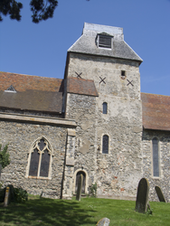
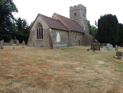
Chislet is today a small village in NE Kent sited between Canterbury and Thanet. The church of St Mary the Virgin has an aisled nave, a blunt Norman central tower and a long aisless chancel. The church owes more to the 13thc than any other period, but there is a Romanesque tympanum to the staircase doorway, chancel arch, and some fragments of unknown date.
Parish church, formerly Benedictine house
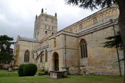
Tewkesbury lies at the northern tip of Gloucestershire, adjacent to the county border with Worcestershire. It is around 15 miles south of Worcester and 10 miles north of Gloucester. The town itself is located on the east bank of the River Avon, at the point where the Avon meets the River Severn. Tewkesbury Abbey stands south of the town centre on a quasi-peninsula formed by the confluence of the River Swilgate, which runs from the east, with the Avon. The area has been prone to flooding over the centuries and especially in recent years. Fortunately the abbey stands on a slightly elevated point, although this has not fully protected the building from flood damage.
Tewkesbury Abbey is regarded as one of the most important Romanesque buildings in the British Isles due to its architectural features and the state of preservation. The church has a cruciform plan comprising an 8-bay aisled nave (with additional 9th bays at the west end of the aisles), aisleless transepts with east-projecting chapels, and a 2-bay chancel flanked by an ambulatory with radial chapels. All of the ambulatory chapels are later medieval constructions. Many alterations were made to the E arm and vaulting throughout the church during the 14thc. There was originally a cloister to the S of the nave as well as other claustral buildings, however these were demolished after the Dissolution.
The abbey was restored by Sir George Gilbert Scott between 1865 and 1879. During this period, the stone screen dividing the nave from the crossing and E arm was removed. One bay of the cloister was reconstructed by Thomas Collins at the end of the 19thc and the W front was repaired in 1906. Various projects were carried out between 1932 and 1938, including repairs to the tower and the strengthening of pier foundations. The site of the E ambulatory Lady Chapel was excavated in 1940 by Sir Charles Peers and Thomas Overbury (the footprint of this structure is marked out on the grass at the E end of the abbey). Major repairs were made to the abbey roofs between 1978 and 1985. The roofs of the eastern chapels were repaired between 1994 and 1996. Repairs were made to the W nave turrets between 1999 and 2002.
Chapel
St Mary's has an aisled and clerestoreyed nave with three-bay
arcades. Of these bay 1 of the S arcade is 13thc. and may, according to Pevsner, have been a
transept arch originally. The rest of the S arcade and the
entire N arcade are either 19thc. in their entirety or heavily
restored work of the years around 1300. The clerestorey windows
are 14thc. The S aisle has been extended E alongside the chancel
to form a chapel, now in use as an organ loft and vestry. The
chancel also belongs to c.1300. At the E end the
lowest part of a tower remains, including a 14thc. window. The spire had fallen in 1703,
and most of the remainder was demolished in 1967. In its place a bellcote was built on top of the west gable. A
date stone of 1601 over the S doorway presumably records a restoration. The church is of
ironstone and grey stone in roughly-coursed blocks. The only Romanesque feature is the
elaborate late 12thc. S doorway.
Chapel
The hamlet of Chesterblade lies in the Mendip Hills 3 miles NE of Evercreech (to which parish it belongs), and 3 miles SE of Shepton Mallet. Its historical significance is suggested by Iron Age earthworks (marked on the OS map as ‘fort’) at Small Down, 800m SE of the church, and the Roman villa which used to occupy the site of the manor farm.
Richard Coates (2006) has argued against Ekwall’s interpretation of the place-name as ‘settlement in a hollow among hills’, pointing out that,
‘ . . . the topography of the village nucleus gives no clear support for an unusual term for a valley or for a ledge to describe its situation -- it is on a gentle slope, and only in the vaguest sense “in a hollow among the hills” as Ekwall claimed. The valleys below the village are no more remarkably bowl-shaped than the typical cumb.'
In its place he offers the interpretation that,
‘ . . . the source of the name Chesterblade, whether applying to the earthworks or the local villa, is explicable as a British Kastron Bladjī ‘stronghold of a/the wolf’ or ‘stronghold of Wolf [proper name]’.’
On a slope running SW between the 180m and the 160m OD contours, the hamlet enjoys good views to the S not much less extensive than those from Small Down. From the chapel on its little rise at the very SW limit of the hamlet, one can clearly see the ridge W of Evercreech which includes Pennard Hill, the Blackdown Hills S and SW of Taunton, Ibberton Hill in North Dorset and even the West Dorset heights of Lewesdon and Pilsdon Pen (Dorset’s highest hill): nearly 30 miles away. The view from the chapel to the W is blocked by no less than the Jurassic height (206m OD) of Maes Down. There is, of course, a very clear view down to the mother church of St Peter at Evercreech.
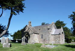
The chapel has work of the 12thc, 13thc and 15thc. It was rebuilt in 1888, and further work was carried out in 1925. Construction is of rubble with some ashlar and freestone dressings. It consists of a nave with a W bellcote and a S porch larger than the tiny chancel. The S doorway is late 12thc, there is a plain 12thc font, and most unusually the ends of the copings and the kneelers of the E and W gables of the nave retain elaborate Romanesque carving.
Parish church
Ludgershall is a village in the Aylesbury Vale district of the county, 12 miles W of Aylesbury and close to the Oxfordshire border. The church is on the S side of the village, on the Brill road, and consists of a chancel, rebuilt in the 14thc, a nave with 4-bay N and S aisles whose arcades are 14thc with some striking capitals carved with large figures with linked arms. The W bays ofthe nave flank the 15thc W tower, and there is a 13-14thc S doorway under a 15thc porch. Construction is of limestone rubble. According to RCHME (1912) the entire church apart from the porch and the chancel were then covered with rough-cast. The only 12thc feature is the font.
Parish church
The village is on the main road A65, between Skipton and Settle. It has farms, Victorian and earlier houses, and a railway station. The church has a W tower, a nave with aisles, and a chancel that was rebuilt in 1868. The arcades seem 14thc. The font is the only remaining Romanesque element.
Parish church
St Mary's is an ashlar church with aisled and clerestoreyed nave, Wtower
and chancel with N vestry. The
nave doorways date fromc.1300; that on the S has a porch, but on the N the doorway now gives access from the
church to a small kitchen and lavatory block added in 1999. The tower has
diagonal buttresses and reticulated bell-openings indicating an early 14thc.
date, and the chancel belongs to the same period. The N
nave arcade is generally early 13thc., but one of its
capitals is either a reused 12thc. piece or very old-fashioned indeed. The S
arcade is 14-15thc. There was a restoration in 1877-78
by Albert Hartshorne of Pinner, when the church was rebuilt except for most of
the chancel, the nave arcades,
and most of the nave S wall. The rogue capital in the N arcade is all that is described
here.
Parish church
Beverston is a hamlet about 2 miles W of Tetbury with the ruins of a 13th-c castle adjacent to the church. The church, which is built of random coursed rubble, is of Norman origin, possibly built on a Saxon site, and was extended in 1225, and again in 1361. It consists of a W tower, a nave with S aisle and 14th-c N (Berkeley) chapel, and a 14th-c chancel. There is a squint passage between the N chapel and chancel. The building was restored in 1844 by Vulliamy, who designed the intricate nave roof. The S doorway and arcade are Romanesque.
Parish church
Little Baddow is a village in the Chelmsford district of the county, 5 miles E of Chelmsford, on the S side of the River Chelmer. The village centre clusters around a network of minor roads between Chemsford and Maldon, 4 miles to the E, but the church and Little Baddow Hall stand outside the village centre, a mile to the NW, St Mary's is constructed of the typical mixture of flint rubble, pebbles, puddingstone and Roman brick. It consists of a chancel, a nave with S porch, and a W tower with an embattled parapet. The nave is 11th-12thc, but the S wall has been rebuilt further S and reroofed, so that it is now asymmetrically placed with respect to the chancel, which, with its c.1350 chancel arch and 15thc windows has clearly been rebuilt in the later Middle Ages. On the exterior of the chancel are 19thc diagonal buttresses of brick. The tower dates from the 14thc and has a N stair turret. Romanesque features are the N nave doorway and a window head re-used as building material in the chancel N wall.
Parish church
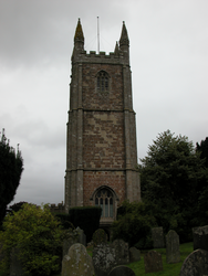
The church, the largest in West Devon, comprises chancel, nave, S aisle and W tower. The chancel is 14thc and the rest of the structure is substantially 15thc and 16thc. It was restored in 1871 (Pevsner 1989, 536; English Heritage listing: 1317823). It is mainly sandstone, with shale, and granite dressings. The only 12thc feature is the font.
