The Corpus of ROMANESQUE SCULPTURE in Britain & Ireland

Cluniac house, former
Cluniac house, former
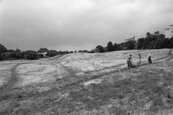
A major monastic site in the Romanesque period, but now not a stone is to be seen. Remains are in hands of museums and in ‘a garden adjoining the site’ (Lockett, 1971, 57, 58). Much stone is said to have been taken in the 16thc. to build the nearby ‘New Hall’, N of the Ferrybridge Road, but this has itself been demolished, see Bellamy (1965, xiii) and Pevsner (1967, 396, 644).
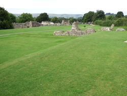
The site is now a large grassed area to the E of the castle. One level area through the middle of the site once included the cloister; a hummocky area to the N was the site of the church. The medieval builders probably terraced the site. In recent years the grass has been mown in order to pick out the areas covered by the church and main buildings. The site was over 8 acres (3.2 hectares) and is approximately bounded by Mill Dam Lane, Ferrybridge Road, Box Lane and Bondgate. The church was over 230 feet (70m) long.
Records for the Priory in the Heritage Environment Records for West Yorkshire (www.heritagegateway.org.uk) give further details on the Priory (monument no. 2088), and New Hall (monument no. 7743).
For the excavations c.1957-1961, see Bellamy (1965), which illustrates some chevron voussoirs with schematic drawings (fig. 23). Sculpture from the excavations was eventually taken to Pontefract Museum in Salter Row and its store (see separate reports).
Cluniac house, former
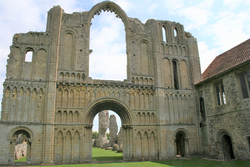
The ruins of the priory lie approximately a quarter of a mile SW of Castle Acre village on low marshy ground near the river Nar. The remains of the castle keep stand on a motte surrounded by a bailey and earthworks on the east side of the village, and the extensive outer defences of the castle enclosed the priory site as well as the village. In the centre of the village is the Bailey Gate, originally the north entrance to the bailey. The extent of the priory enclosure can be gained from the position of the gatehouse of c.1500, to the north of the priory church. The layout of the monastery is still clearly discernible.
There are impressive standing remains, especially of the facade of the 12thc. church. This had a nave of seven bays and a choir of two, both aisled. The E end was triapsidal. A pair of towers surmounted the westernmost bays of the nave aisles. There was a crossing tower and transepts, the latter with an apsidal chapel apiece. The walls of the nave and transepts stand to a height of several feet in places. The plan, and in some cases, ornament of the nave piers (exceptionally varied, as a group) are still discernible. What survives of the south arcade are the arch, gallery and upper storey of the westernmost bay (bay 7), forming the north face of the SW tower, together with slight remains of bay 6, sufficient to suggest that the elevation of bay 7 was repeated along the length of the nave. For the rest, both nave arcades have been completely destroyed, and what appear to be survivals are in fact reconstructions. In the north arcade, the base and part of the shaft facing of pier 6 has been reconstructed. Further east in the same arcade, a rubble construction representing the cores of piers 1 and 2, with the arch between them and the lower part of the gallery opening above has been erected for educational purposes. Substantial architectural sculpture remains on the W facade, especially in the portal zone, and on the SW tower.
The cloister is to the south of the nave, and although its arcades are gone there are substantial remains of the monastic buildings. On the east range the chapter house stands south of the transept, then come the dorter and rere-dorter, which extend southward beyond the square of the cloister. The refectory was in the south range, and the west was occupied by cellarage below and the guest house and prior's lodging above. The prior's quarters were at the north end of this range, alongside and immediately SW of the west facade of the church. They consist of a parlour and a cellar on the ground floor, and a chapel and solar above. In the centre of the west range is a two-storey porch. The parlour and chapel are 12thc work, but the west cellar and the solar above it belong to a campaign of c.1500, and the porch was also enlarged about this time. The prior's lodging continued in occupation after the dissolution. Further alterations were made including the installation of fireplaces. Both the chapel and the porch were converted to domestic use. Isolated decorated elements survive in situ on the vestigial Romanesque monastic buildings, principally the parlour and the chapter house. A number of carved fragments are (or were in 1985) displayed in the W range of the cloister.
Cluniac house, former
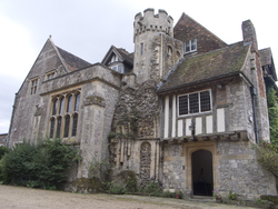
The Cluniac priory of Horton is one of the few monastic sites in Kent, apart from the two cathedrals, with significant remains above ground. It lies in open countryside about 5 miles NW of Hythe. The priory was probably built in the late 12thc, with alterations in the 14thc to 15thc. Elements of the priory have been incorporated into a substantial private house which owes much of its current appearance to alterations in 1913-14. These features include the lower parts of the W front on the N side; the beginning of the S aisle with a stair turret, and the W range. There are no traces above ground of the N side of the nave, the rest of the church or the claustral ranges and gatehouses. However, several doorways and many reset fragments preserved as decoration indicate that this was a large and richly sculpted site. The fieldworkers are particularly grateful to Mrs Margaret Bonsall for allowing them to visit her beautiful and elegant house for CRSBI.
Cluniac house, former
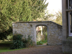
Today Tickford Abbey is a residental care home on the northern edge of Tickford End, that part of Newport Pagnell that lies on the E bank of the river Great Ouse. The present house is a square 18thc building in substantial grounds were remains of the former priory have been found. Behind the house, to the NE of it, is a walled garden, and inside this at the W end carved stones from the priory have been assembled in a rectancular frame built into the wall. Most are dogtooth (i.e. early 13thc) but three stones are carved with elaborate point-to-point chevron, and these are described below.
Cluniac house, former
Lewes was the county town of Sussex before the county was divided in 1974, and is now the county town of East Sussex. It stands on the River Ouse, 6 miles NE of Brighton. The ruins of the priory are in Southover, on the SE edge of the town and are now bisected by the East Coastway rail line. Most of the priory site is occupied by Priory Park, on the S of the railway. The priory constructed by William de Warenne consisted of the great church with its cloister to the S bounded by the refectory on the S range. S of this stood the rere-dorter, later extended with a new block to the E, and the Infirmary. The site was bounded on its southern edge by the Cockshut stream, a tributary of the Ouse which provided the water supply. The Infirmary chapel, built to the S of the eastern arm of the great church on a slightly different axis, is assumed to be the first Cluniac church on the site. Its postion allows the visitor to locate the position of the great church itself, of which there are no standing remains except for the S wall of the SW tower, lying as it does below the railway line and the privately-owned land to the N of it. When the railway was built in 1846 the foundations of the church were revealed, enabling St John Hope and Breakspear to produce a plan (Hope 1884). The best description of the standing remains will be found in VCH (1940).
The only sculptural remains in Priory Park are reused in the Prospect Tower, a cylindrical, battlemented tower built at the W end of the park. Carved and moulded voussoirs from the priory are incorporated into a doorway and two of the window arches.
